
It is not easy to imagine either the appearance of the riverside or the rural condition of the mother parish of Stepney four hundred years ago, when it was possible to view afar over field, meadow and marsh the little ships of sail passing up and down the silver reaches of the Thames, with the green hills of Kent and Surrey beyond.
To-day most of that which is seen in the streets of East London has been developed since the making of the great docks early in the nineteenth century and the building of wharves and warehouses. The beginning of the change that altered the character of the whole district occurred, however, in the second half of the sixteenth century, in the days of Queen Elizabeth, when England, awakened by the spirit of adventure, took to the sea, and laid the foundations of its maritime power, the Indian Empire, and the oversea Dominions. In this great enterprise Stepney played no mean part. In the words of honest John Strype:
"It is further to be remarked that the Parish of Stepney, on the Southern Parts of it especially, that it is one of the greatest Nurseries of Navigation and Breeders of Seamen in England, the most serviceable Men in the Nation; without which England could not be England for they are its Strength and Wealth."
Previous to this era there was, between the Precinct of St. Katherine's by the Tower and Blackwall (just under six and a half miles) nothing but marshland, having a sparse population, except at Ratcliff, where from time immemorial people had gathered and carried on waterside occupations. It occupied a favourable position, having a low cliff with a foreshore lying in the curve of the river where the straight run of tides without eddies caused no silting up of mud and gave a depth of water suitable for its use as a quay. At the western end of this convenient stretch of foreshore, the extent of which corresponds with the present Broad Street, stood a slight eminence sometime named Cock Hill, while at the other was Ratcliff Cross, with its stairs and hardway giving access to the water at all states of the tide. Nearby there was a small inlet now filled in, which in later years was known as Ratcliff Dock. The natural advantages of the situation were recognised in the Roman times when a causeway was made across the marshes from Tower Hill along the line which centuries afterwards was to become the notorious Ratcliff Highway.
The origin of the name of Stepney has given rise to some speculation, but it is generally accepted that the derivation is from Steben and hythe, although the variant spelling Stebonheath has had a misleading effect. Apart from the doubt whether Steben refers to a personal name - Stephen - or to a Saxon word "steb," meaning timber, the hythe or wharf, is not strongly disputed. As there appears to have been no other appropriate place elsewhere the hythe would seem to have related to the foreshore at Rateliff.
In the beginning of the sixteenth century, in the time of Henry VIII, "the town" of Ratcliff had become of considerable importance, and had numerous inhabitants who were engaged in the trades and occupations peculiar to riverside life. Evidence in support of the place being populous is the choice of it by Nicholas Gibson, citizen and grocer, for founding, in 1538, a free school for sixty boys and almshouses for fourteen aged poor persons. His widow married Sir Anthony Knyvett, and on his decease, for the continuance of the Charity, provided for it being vested in the Company of Coopers. Lady Avice Knyvett and her two husbands are buried in Stepney Church, and the site of the school is pre served in the name of the still existent Schoolhouse Lane.
The importance of Ratcliff is stressed in parochial affairs by the fact, which is not widely known, that the parish church of St. Dunstan and its large churchyard stands wholly within it. Near the church was the large house, The Great Place as it was called, where Sir Henry Colet lived. His son John Colet, Dean of St. Paul's, and founder of St. Paul's School, while he was Vicar of Stepney, was visited on more than one occasion by the great and learned Dutch scholar Erasmus, whose impressions of Stepney as a place of residence at that time are happily preserved in a letter to his friend:
"I come to drink your fresh air, my Colet, to drink deeper of your rural peace. Wherever you look, the earth yieldeth you a pleasant prospect, the temperature of the air fresheth you, and the very bounds of heaven do delight you. Here you find nothing but bounteous gifts of Nature and saint-like tokens of innocency."
These remarks might be taken as savouring of polite exaggeration, but there is confirmation of their literal worth to be found in a letter of Sir Thomas More, who alludes to the delights afforded by "the country about your parish of Stepney."
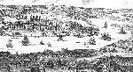 From
a panoramic map of London and its suburbs made in 1543 a section has been reproduced (left)
to assist our readers in obtaining some idea of the aspect of the southern part of the old parish
of Stepney abutting on the river. Considered as an actual representation, the picture may seem
to be slightly out of perspective, but it should be borne in mind that in its compilation the
mental impressions of the various places shown were relied upon from the imaginary position
above the monastery of Bermondsey, part of which is seen in the foreground.
From
a panoramic map of London and its suburbs made in 1543 a section has been reproduced (left)
to assist our readers in obtaining some idea of the aspect of the southern part of the old parish
of Stepney abutting on the river. Considered as an actual representation, the picture may seem
to be slightly out of perspective, but it should be borne in mind that in its compilation the
mental impressions of the various places shown were relied upon from the imaginary position
above the monastery of Bermondsey, part of which is seen in the foreground.
Across the river there is unmistakably the Tower of London, behind which, within the city wall, is Tower Hill with the place of execution; and continuing along the wall there is Aldgate surmounted with three heads of criminals stuck on poles, and to the right is the former church of St. Botolph. The road into Essex is indicated passing through Whitechapel to Mile End, and thence to the left of Stepney Church. The gateway in the city wall, the one nearest the Tower, is the Postern Gate, from whence began the highway across East Smithfield to Ratcliff. East of the Tower is the Church and Hospital of St. Katherine, with houses clustered on three sides. On the further, the East side, marshland extends to Cock Hill. Beyond Ratcliff in the next curve of the river is the low-lying Isle of Dogs, opposite which is seen a small part of the old Palace of Greenwich.
St. Katherine's by the Tower owes its name to the Hospital founded about 1148 by Queen Matilda, wife of Stephen, who created and endowed it in the time of her grief over the loss of her two children who died and were buried in the Church of Holy Trinity, Aldgate. At this time, it may be remarked, there was a vineyard in the vicinity.
Under the shadows of the Hospital there grew up a populous neighbourhood, which, when the map was made, was largely composed of foreigners, mostly Flemish and Dutch, or persons of foreign extraction. They carried on their trades near, yet outside, the city from which they were excluded as aliens. Here on the quayside the little ships from Holland landed their goods and took on board cargoes for their homeward voyage. Beer was one of the commodities thus shipped. Much of it was brewed in the locality, and the water of the Thames long enjoyed a high reputation for its value. Stow remarks that "the brewers remain to the friendly water of the Thames." In the narrow circuitous Nightingale Lane leading from East Smithfield to the banks of the river stood one of these breweries. "This part of the public sustenance," it is recorded, "was subject to regulation as early as Henry VII who, in 1499, licenced John Merchant, a Fleming, to export 50 tuns of Ale called Berre, and in the same reign one Geoffrey Gate, probably a King's officer spoiled [took possession of] the brew-houses at St. Katherine's twice, either for sending too much abroad or brewing it too weak for home consumption." There was a steady demand for this article from foreign parts, and even when there was a scarcity of corn (which, it may be noted in passing, was grown at this time in the neighbourhood of Whitechapel) its exportation was permitted by Royal Licence. The King's brewhouse on the east of St. Katherine's stood at a place which bore the name of the Hermitage, where a small chapel sometime stood for prayer for the preservation of the embank ment or river wall.
The whole inhabited area of St. Katherine's was a network of tangled lanes with wooden-built habitations. The Precinct, which was originally deemed to belong to the Portsoken Ward of the City, became within the jurisdiction of the Tower, and as one of the Liberties was included in the Tower Hamlets. In this way it became part of the Borough of Stepney. Just over a hundred years ago the Hospital was pulled down, together with some 1,250 houses of the poorest and meanest description, and 11,800 inhabitants displaced, to make St. Katherine's Docks, which now occupy twenty-four acres of the site.
by Sydney Maddocks