
It may be doubted if anyone has in recent times walked on a single occasion the entire length of Old Ford Road, the two and a quarter miles from Bethnal Green by the Museum to where it emerges at Bow at the north-eastern angle of the Parish Church. The performance of an unbroken journey would suggest the idea that it must have been done for a wager, or at least an unusual curiosity had been provoked and gratified. As for vehicular traffic the case is perhaps somewhat different, but the odds are that any entering the road at Bethnal Green would, on approaching the main highway into Essex, choose the straight continuation of the thoroughfare, passing from it into Payne Road rather than complete its last ninety yards, which gives a twist and turn in ending its weary length. Regarding traffic going in the opposite direction, it is difficult to understand why vehicles should be induced to turn into Old Ford Road at Bow Church in order to reach Bethnal Green.
In fact, Old Ford Road really represents two separate ways from different points to the sometime passage across the Lee, one being from the west, the other from the south, which in meeting converged with a third from the north which is known now as Wick Lane, the communication with Hackney.
In ancient times the estuary of the river Lee extended as far as Hackney Wick, and during the period when the Romans were in Britain the marshes which lay above it and on either side were crossed in the direction of Leyton by a stone causeway of which portions have been found, but of any contemporary road leading to it no traces have been discovered, although Roman remains were unearthed in 1868 in the coal and goods yard attached to Old Ford Station. The probability is that there was no military highway of massive construction such as those found elsewhere, but a track formed by use which led through woods and over the open fields to the first fordable place on the river Lee or Lea, a name derived from the Saxon lygan meaning fast-flowing. This route, it may be conjectured, was followed for centuries, and varied only when the changes in the channels of the river affected the situation of the ford.
More than a thousand years ago bands of Danish marauders sailed up the Lee as far as Hertford, a place then of greater strategic importance than London. There they built a fort to which they retired after being attacked and defeated by the Londoners. Alfred known as 'the Great' was king of the West Saxons, and he, to prevent the return of the invaders' shipping and their escape by the Thames, conceived the design of cutting channels in the river by which the waters would be lowered sufficiently to leave the vessels aground. The project was successful, and the Danes fled inland northwestward, and for long afterwards the country was free from such incursions. This work of Alfred, however, destroyed the navigation of the river, and although in the middle of the fifteenth century a plan was put forward to restore it, the troubles of the time prevented the proposal from being carried out. A hundred years or so later, in 1571, the thirteenth year of the reign of Elizabeth, an Act was passed for making a new cut or trench within ten years at the expense of the Lord Mayor, commonalty and citizens of London in order to convey grain and provisions for the capital. The work was completed, and in 1767 the navigation was further improved, but the old river-bed from which the water had been partially diverted between Stratford, Bow and Hackney Wick still remained. Two of the old channels are represented by the watercourses which can be seen at the present time undergoing alteration in connection with the widening of High Street, Stratford.
In the Norman period of our history the ford joined the manors of Stepney and Wanstead, for the latter extended to the Lee by a narrow strip of land which still bears the name of Wanstead Slip, although it has been included for many years in the district of Leyton. Both manors were then held by the Bishop of London, so the way eastwards from the city by Norton Folgate as far as the river Roding went over lands attached to St. Paul's.
The story of Queen Matilda, wife of Henry I, who got a sousing at the ford - likely enough on a journey between London and Barking - is well known. It was a misadventure which led to the building of Bow Bridge, half a mile to the south, but it should not be inferred that the old way into Essex thereby became superseded. For long afterwards it retained its importance, for, except in times of great floods, it would be chosen by those who rode horseback, for the greensward was ever preferable to the rough, ill-maintained roads, the condition of which can be little imagined in the present day. The position of the ford is to be located by the angle of Old Ford Road, a spot near to where the Northern Outfall sewer crosses the river.
 A
curious tradition associated with Old Ford was that King John had a castle there, and that it
was the place where he slept after granting the Magna Carta. No evidence is to be found to support
this legend, and there is no record of the place having belonged to the Crown; indeed, it was
included in the Manor of Stepney. There appears to have been some remains of an ancient edifice
which a storm blew down on 24 January 1800, but the building known as King John's Palace, which
stood in the vicinity of the ruins, survived until 23 September 1863, when it was destroyed
by fire. It was a twelve-roomed building described as "standing on a kind of terrace, with elaborate
chimney-pieces and a large oaken staircase," and was said to have been a famous hostelry in
the days when travellers still chose the route by the old ford in their passage between London
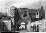
and Essex. The illustration [left] shows the gateway, about 1793, of the premises which
have been identified as having been styled in Elizabethan times as the Great Place, and in 1665
as being owned by William Williams, a citizen of London. The property, which included the mansion,
is supposed to have been known as Gissing Place or Petersfield, which, with twelve acres of
land, was conveyed in 1418 by John Gest to Humphrey Duke of Gloucester and others, who held
it but for a year. The site of the Place or Palace is shown on the Ordnance map (1894-6) as
being on the south side of the road east of Wick Lane.
A
curious tradition associated with Old Ford was that King John had a castle there, and that it
was the place where he slept after granting the Magna Carta. No evidence is to be found to support
this legend, and there is no record of the place having belonged to the Crown; indeed, it was
included in the Manor of Stepney. There appears to have been some remains of an ancient edifice
which a storm blew down on 24 January 1800, but the building known as King John's Palace, which
stood in the vicinity of the ruins, survived until 23 September 1863, when it was destroyed
by fire. It was a twelve-roomed building described as "standing on a kind of terrace, with elaborate
chimney-pieces and a large oaken staircase," and was said to have been a famous hostelry in
the days when travellers still chose the route by the old ford in their passage between London
and Essex. The illustration [left] shows the gateway, about 1793, of the premises which
have been identified as having been styled in Elizabethan times as the Great Place, and in 1665
as being owned by William Williams, a citizen of London. The property, which included the mansion,
is supposed to have been known as Gissing Place or Petersfield, which, with twelve acres of
land, was conveyed in 1418 by John Gest to Humphrey Duke of Gloucester and others, who held
it but for a year. The site of the Place or Palace is shown on the Ordnance map (1894-6) as
being on the south side of the road east of Wick Lane.
At one time the disagreeable occupation of fulling of cloth was carried on at Old Ford, but most likely on the Essex side of it, where there was the abundance of water necessary for the process of removing the grease and cleansing the material. The neighbourhood on the Middlesex side until the great change came in the middle of the nineteenth century was rural and pleasant. It continued until then to be the resort of those who delighted in the countryside just as it had been of those of former generations. Thomas Dekker, the dramatist, in his play "The Shoemakers Holiday," written in 1599, placed some of the scenes at Old Ford, where the deer was chased through the thicket and brushwood. This playwright, who had a peculiarly wide acquaintance with the city and the suburbs, selected this spot for his Lord Mayor's country house, where in the garden the citizen's daughter sat and thought of her lover amid pinks, roses, violets, blushing gilliflowers and marigolds. Samuel Pepys records his visits:
1664, June 11th.
"...and thence after dinner by coach with my wife only to take the ayre, it being very warm and pleasant, to Bowe and Old Ford: and thence to Hackney. There 'light, and played at shuffle-board, eat cream and good cherries; and so with good refreshment home..."
1668, 2nd June.
"Up, and to the office, where all the morning. At noon home to dinner, and there dined with me, besides my own people, W. Batelier and Mercer, and we very merry. After dinner, they gone, only Mercer and I to sing a while, and then parted, and I out and took a coach, and called Mercer at their back door, and she brought with her Mrs Knightly, a little pretty sober girl, and I carried them to Old Ford, a town by Bow, where I never was before, [Pepys was in error; he had already visited Old Ford on 11 June 1664.] and there walked in the fields, very pleasant, and sang: and so back again, and stopped and drank at the Gun, at Mile End, and so to the Old Exchange door, and did buy them a pound of cherries, cost me 2s., and so set them down again..."
1669, 7th May.
"Thence with my wife abroad, with our coach, most pleasant weather; and to Hackney, and into the marshes, where I never was before, and thence round about to Old Ford and Bow; and coming through the latter home, there being some young gentlewomen at a door, and I seeming not to know who they were, my wife's jealousy told me presently that I knew well enough it was that damned place where Deb. dwelt, which made me swear very angrily that it was false, as it was, and I carried [her] back again to see the place, and it proved not so, so I continued out of humour a good while at it, she being willing to be friends, so was I by and by, saying no more of it..."
In the eighteenth century the attractions of the place were enhanced by the popularity of cakes, ale, watercress and cream to be had there, and it became also famous for its eel pies, which, it is related, "were unmercifully devoured at Clay Hall near Bow."
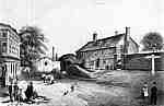 The
picture which appears [to the right] presents the aspect of Old Ford Road at the junction
of Wick Lane, about ten years after the destruction of the Palace, that is to say about 1872.
The group in the foreground may at first be thought a picnic party, but it is really an interlude
in the work of those excavating the road, and the lady and gentleman who have taken up an odd
position are viewing something with evident interest and curiosity. On the other side an old-fashioned
top-hatted constable is on duty, scarcely to regulate the traffic, for all there is consists
of a solitary hooded wain about to take the lane to Hackney, as indicated by the guide post,
which also points the directions to Shoreditch and to Bow. On the left-hand side is the White
Hart public house, which has since changed very little in its appearance, but the old dwellings
opposite have long since disappeared. In the distance, where the road begins to take a turn,
is a small arched opening in the wall once known as the Ivy Gate, which is said to have belonged
to the Palace. If this were so the road or lane here to the ford must have, at some time, passed
beyond on the other side of the wall. The crumbling arch of the Ivy Gate was removed in about
the year 1896, but portions of the support still remain. It was once a favourite trysting place,
and in the moonlight it seemed a romantic spot, the road being deserted after nightfall. Pedestrians,
to avoid the lonely bend of the road, would take the short cut into Atley Road by going through
Sounding Alley - an alley which, to those who recall the Afghan War, served in their boyhood
as a pass to be attacked or defended as the case might be.
The
picture which appears [to the right] presents the aspect of Old Ford Road at the junction
of Wick Lane, about ten years after the destruction of the Palace, that is to say about 1872.
The group in the foreground may at first be thought a picnic party, but it is really an interlude
in the work of those excavating the road, and the lady and gentleman who have taken up an odd
position are viewing something with evident interest and curiosity. On the other side an old-fashioned
top-hatted constable is on duty, scarcely to regulate the traffic, for all there is consists
of a solitary hooded wain about to take the lane to Hackney, as indicated by the guide post,
which also points the directions to Shoreditch and to Bow. On the left-hand side is the White
Hart public house, which has since changed very little in its appearance, but the old dwellings
opposite have long since disappeared. In the distance, where the road begins to take a turn,
is a small arched opening in the wall once known as the Ivy Gate, which is said to have belonged
to the Palace. If this were so the road or lane here to the ford must have, at some time, passed
beyond on the other side of the wall. The crumbling arch of the Ivy Gate was removed in about
the year 1896, but portions of the support still remain. It was once a favourite trysting place,
and in the moonlight it seemed a romantic spot, the road being deserted after nightfall. Pedestrians,
to avoid the lonely bend of the road, would take the short cut into Atley Road by going through
Sounding Alley - an alley which, to those who recall the Afghan War, served in their boyhood
as a pass to be attacked or defended as the case might be.
by Sydney Maddocks